Continent wall treatment: How To
After sharing a sneak-peek at Oliver's nursery last week, I had a few people ask about how we ultimately decided to go about painting the continents. This tutorial will probably be boring to some of you, but I promise I'll be back with something fun tomorrow: a reader design dilemma about mixed-gender shared kids rooms. Good stuff.
First, I should say that Oliver's parents finally decided to go for the map treatment we had been considering after I showed them a picture of Max's room, over at Janell's blog. They could finally visualize it in a room, and with the more neutral color palette we decided to go big and use all the walls, not just the alcove.
Okay, so I considered a number of options before we proceeded paint. I thought freehanding the maps would be fine (I'm such a dork, I used to draw freehand maps for fun), except we were doing all the continents, on sloped walls, and I thought the overall perspective would get off if I made it up as I went along. Next I considered using that trick where you draw a grid over your image and draw a corresponding grid on your wall in order to keep your perspective in line, but I didn't want to deal with erasing the grid lines from the original wall color. Plus I wanted to get a sense of the placement before I made ANY marks. The whole thing became much simpler once I decided to just go ahead and invest in a projector. (Believe me, I can see many uses for this thing!)

After reading lots of reviews, I chose the tracer from artograph because the viewfinder window is 5 inches (meaning, it can project an original image that is 5 x 5 inches; lots could only do 3", which really isn't very much) and because it could enlarge that image up to 14 times. Since I knew I was planning on continents that were several feet tall, this was completely necessary. Also, it was reasonably priced. They go for anywhere from $49 into the $80s, depending on where you buy.
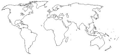
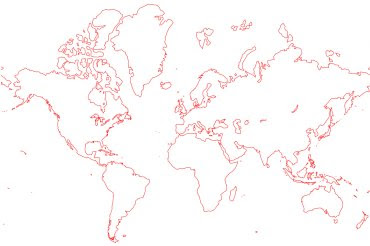
To get my map source material, I did a google image search for "world map outline," knowing that it would be simplest to deal with a single, strong outline and not something more detailed so I wouldn't have to figure out what to keep in and what to leave out as I was tracing it to the wall. I found a few that had the right level of detail to the outline and the right shape on the page (some were more slanted than others, especially North America.) One weird word of warning: lots of map sites seem to carry viruses, so my Norton was pretty busy.
Once I had my images, I just copied them to be a full page on standard 8 1/2 x 11 paper, printed them out, and, where necessary, drew over the outline with a fine-tip marker to make it bolder--the projector is not all that powerful.


The projector called for a REALLY dark room, and we did end up taping cardboard over the windows. I played around until we found the right size and placement on the wall, propping the projector on a box, propping the box up with books, and moving the whole contraption closer to and farther from the wall until we got it just right. It's a good idea to tape the picture down to your surface and mark the projector's placement on the paper--just trace around the corners of the projector with a pencil--because the thing can definitely slip. I learned the hard way that trying to realign the image on the wall is nearly impossible.
Once all of that preparation was done, I simply used a pencil and traced the outline of the map right on the wall.

That's florida.
Next, we used a mini foam roller and some wide, flat artist brushes to paint in the continents with our main color--a no-VOC paint in "Coastal Sand," which seems quite fitting. The paint was regular latex interior housepaint in an eggshell finish, same as the walls. We gave it two coats. This was easy but time consuming.

There's Australia, all coastal sandy.
Finally, we came back in with a dark brown paint to edge everything out. I used a brush from my kids' watercolors (we have plenty of extras from used-up paint sets), and cut it down by half or more so the bristles would be firm--before I did this, I found that some of the bristles went rogue and gave a sloppy line. I was able to adjust the level of detail to the edges in this step for the best effect.

And voila, Australia and assorted Pacific islands.
So there you have it. As with so many things, the better prepared you are, the easier the project will be.
Oliver's grandma is finishing up one final sewing project for the room and bringing it up next weekend, so I should be able to share the final "after" next week. It's looking good, and we're excited!
First, I should say that Oliver's parents finally decided to go for the map treatment we had been considering after I showed them a picture of Max's room, over at Janell's blog. They could finally visualize it in a room, and with the more neutral color palette we decided to go big and use all the walls, not just the alcove.
Okay, so I considered a number of options before we proceeded paint. I thought freehanding the maps would be fine (I'm such a dork, I used to draw freehand maps for fun), except we were doing all the continents, on sloped walls, and I thought the overall perspective would get off if I made it up as I went along. Next I considered using that trick where you draw a grid over your image and draw a corresponding grid on your wall in order to keep your perspective in line, but I didn't want to deal with erasing the grid lines from the original wall color. Plus I wanted to get a sense of the placement before I made ANY marks. The whole thing became much simpler once I decided to just go ahead and invest in a projector. (Believe me, I can see many uses for this thing!)

After reading lots of reviews, I chose the tracer from artograph because the viewfinder window is 5 inches (meaning, it can project an original image that is 5 x 5 inches; lots could only do 3", which really isn't very much) and because it could enlarge that image up to 14 times. Since I knew I was planning on continents that were several feet tall, this was completely necessary. Also, it was reasonably priced. They go for anywhere from $49 into the $80s, depending on where you buy.
To get my map source material, I did a google image search for "world map outline," knowing that it would be simplest to deal with a single, strong outline and not something more detailed so I wouldn't have to figure out what to keep in and what to leave out as I was tracing it to the wall. I found a few that had the right level of detail to the outline and the right shape on the page (some were more slanted than others, especially North America.) One weird word of warning: lots of map sites seem to carry viruses, so my Norton was pretty busy.
Once I had my images, I just copied them to be a full page on standard 8 1/2 x 11 paper, printed them out, and, where necessary, drew over the outline with a fine-tip marker to make it bolder--the projector is not all that powerful.
The projector called for a REALLY dark room, and we did end up taping cardboard over the windows. I played around until we found the right size and placement on the wall, propping the projector on a box, propping the box up with books, and moving the whole contraption closer to and farther from the wall until we got it just right. It's a good idea to tape the picture down to your surface and mark the projector's placement on the paper--just trace around the corners of the projector with a pencil--because the thing can definitely slip. I learned the hard way that trying to realign the image on the wall is nearly impossible.
Once all of that preparation was done, I simply used a pencil and traced the outline of the map right on the wall.

That's florida.
Next, we used a mini foam roller and some wide, flat artist brushes to paint in the continents with our main color--a no-VOC paint in "Coastal Sand," which seems quite fitting. The paint was regular latex interior housepaint in an eggshell finish, same as the walls. We gave it two coats. This was easy but time consuming.

There's Australia, all coastal sandy.
Finally, we came back in with a dark brown paint to edge everything out. I used a brush from my kids' watercolors (we have plenty of extras from used-up paint sets), and cut it down by half or more so the bristles would be firm--before I did this, I found that some of the bristles went rogue and gave a sloppy line. I was able to adjust the level of detail to the edges in this step for the best effect.

And voila, Australia and assorted Pacific islands.
So there you have it. As with so many things, the better prepared you are, the easier the project will be.
Oliver's grandma is finishing up one final sewing project for the room and bringing it up next weekend, so I should be able to share the final "after" next week. It's looking good, and we're excited!
